A wind map up to 14 days ahead, NOAA nautical charts with your GPS position, the marine forecast from your local NWS office, live buoy reports, tides and currents: everything you check before leaving the dock, in one app for your home waters. One-time purchase. No subscription, no account, no ads.
The wind map and NOAA charts cover US waters wherever NOAA publishes a chart. The marine forecast, live buoy reports, tides and currents are per region: 30 regions so far, listed below. If your home waters aren't there yet, request them at windandtides.com.
Built for boating, sailing, fishing, kayaking, paddleboarding, windsurfing, wing foiling, kiteboarding, and open water swimming. Sailors have used Wind and Tides since 2011, and the marine and weather forecasts, tides, currents and buoy reports each link back to their NOAA source page.
SUPPORTED REGIONS
California
• San Francisco Bay
• San Francisco Offshore
• Monterey Bay
• Morro Bay and Port San Luis
• Santa Barbara
• Los Angeles
• Catalina and Channel Islands
• Newport Beach and Dana Point
• San Diego
Pacific Northwest
• San Juan Islands
• Port Angeles
• Port Townsend
• Puget Sound
Hawaii
• Honolulu and Oahu South Shore
Northeast
• Portland Maine and Casco Bay
• Boston and Massachusetts Bay
• Cape Cod Bay and Plymouth
• Buzzards Bay and New Bedford
• Martha's Vineyard and Nantucket
• Newport and Narragansett Bay
• Block Island
• Long Island Sound East
• Long Island Sound West
Mid-Atlantic
• Chesapeake Bay North
• Chesapeake Bay South
Florida and Gulf Coast
• Fort Lauderdale
• Miami and Biscayne Bay
• Tampa Bay and St. Petersburg
• Pensacola
• Galveston Bay
WHAT'S INSIDE
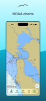
• NOAA ENC nautical charts: depths, hazards, buoys, channel markers, with your GPS position, course and speed
• Wind map: speed and direction animated over the chart, up to 14 days ahead
• NWS coastal waters forecasts from your local forecast office: wind, seas, small craft advisories, and gale warnings through day 5
• NOAA tide predictions
• NOAA current predictions
• NDBC live buoy observations
• NWS gridded weather forecasts
• Wind models: NOAA HRRR, NBM, and GFS; ECMWF open data
Wind and Tides surfaces public NOAA, NWS, and NDBC data and ECMWF open data, and is not affiliated with these organizations.
Don't see your region? Request it at windandtides.com.


 +3
+3



