TACTICAL MAP PRO
PROFESSIONAL TACTICAL GPS NAVIGATION
Tactical NAVIGATION is a professional field tool offering GPS navigation and map management at military standards. It meets all your needs in a single application for off-road drivers, mountaineers, military personnel, search and rescue teams, hunters, radio amateurs, and aviators.
Works without internet. Your data stays on your device. Ad-free.
MULTI-LANGUAGE SUPPORT
Worldwide support with 32 languages:
Turkish, English, German, French, Spanish, Italian, Dutch, Portuguese, Polish, Norwegian, Bulgarian, Croatian, Lithuanian, Romanian, Slovak, Slovenian, Ukrainian
Chinese, Japanese, Korean, Hindi, Indonesian, Malay, Thai, Filipino (Tagalog)
Arabic, Persian, Russian, Azerbaijani, Kazakh, Uzbek
Afrikaans
ONE-TIME PURCHASE, FULL ACCESS – NO SUBSCRIPTIONS! There are no monthly or yearly subscription fees, no in-app purchases, and no hidden costs. Pay just once and get lifetime access to all advanced professional features—like offline maps, MGRS, and tactical tools—that other apps lock behind a paywall.
1. LOCATION
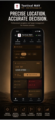
Your GPS location in 5 different coordinate formats simultaneously:
- MGRS (Military Grid Reference System) 1 meter precision
- UTM (Universal Transverse Mercator)
- USNG (US National Grid)
- QTH (Maidenhead Locator for radio amateurs)
- BNG (British National Grid)
- LAT/LON (decimal degrees)
2. MAP
Switch between 6 different map layers:
- OpenStreetMap (street)
- Satellite (high resolution)
- Topographic (with contour lines)
- Hybrid (satellite + names)
3. TARGETS
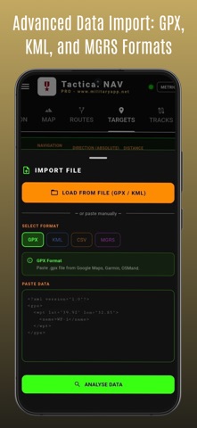
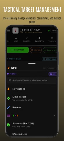
Bulk import: GPX, KML, KMZ, CSV, MGRS text format. Each target is marked with a red pin, tap to start navigation. Target name, coordinate, description, and category (green/yellow/red/blue tag) can be edited.
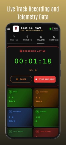
4. TRACKS
Start track recording with a single touch. Works even when the screen is off (foreground service). Pause / Resume / Stop. Automatically calculated statistics:
- Distance traveled
- Average and maximum speed
- Total ascent and descent
- Elevation profile graph
The track is colored on the map according to speed (green-slow, red-fast). Export as GPX or view on the map.
5. COMPASS
Military style digital compass. Absolute and relative direction (bearing) to the active target in real time. The compass automatically locks to the active route, deviation warnings appear.
6. TOOLS
- COORDINATE CONVERTER LAT/LON MGRS UTM USNG QTH mutual conversion
- AREA CALCULATOR draw polygon on map
- DISTANCE MEASURER distance and bearing between two points
- OFFLINE MAP DOWNLOADER select region, download
7. WEATHER
Detailed 7-day weather forecast based on your location.
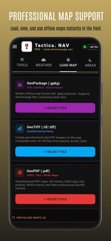
8. LOAD MAP (OFFLINE MAP)
- MBTiles Most common offline format, fast, single file
- GeoPackage (.gpkg) OGC standard, SQLite based
- GeoTIFF (.tif/.tiff) Satellite/aerial photo (Avenza, ArcGIS, QGIS)
- GeoPDF (.pdf) USGS topography, FAA aviation, NOAA maritime, military maps
9. ROUTES
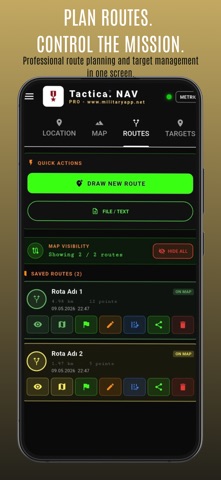
Saved route management center. Load GPX/KML file, draw manually, or paste text. Multiple routes are displayed on the map at the same time, automatic color palette. Route editing: move point, delete, add waypoint, split/merge segment. START MISSION compass locks to the route, track recording opens automatically, ETA is calculated.
10. AREAS
Area measurement by drawing polygons on the map. Perimeter calculation. View multiple areas at the same time, separate with color palette. Ideal for agriculture, land, hunting ground, mission area planning. Export as GPX/KML.
11. BRIEFING
Freehand drawing tool on map for field briefings. Visually mark attack directions, safe zones, critical points, and roads. Color palette (10+ colors), thickness selector (3 levels). Draw with one finger, pan/zoom map with two fingers. Show/hide multiple briefings at the same time, name, delete, share with teammates.
PRIVACY & SECURITY
Your location data is stored ONLY on your device
Not sent to any server
Not shared with any third party
Ad-free, no advertising network