Trusted by GA pilots across the US. Real aviation weather, your personal minimums, and a clear go/no-go recommendation in under 10 seconds. No ads.
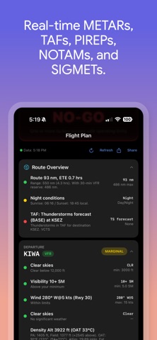
Flyable is a preflight decision aid for general aviation pilots. In under 10 seconds, you get METARs, TAFs, PIREPs, NOTAMs, and SIGMETs for your route — filtered against your personal minimums and aircraft performance — with a clear GO, MARGINAL, or NO-GO recommendation.
Select your aircraft. Enter your departure, destination, waypoints, and alternate. Tap Evaluate. Flyable pulls real-time data from official FAA sources and checks every factor against the limits you've set: ceiling, visibility, crosswind, gusts, tailwind, turbulence, icing, thunderstorms, density altitude, runway length, and more.
No subscription. No account. No ads. Just a straightforward weather briefing tool built by a pilot, for pilots.
WEATHER DATA
• Live METARs with flight category (VFR/MVFR/IFR/LIFR) — stale observations flagged with their age
• Terminal Aerodrome Forecasts (TAFs) evaluated for your actual flight window
• Pilot Reports (PIREPs) within 100 nm, filtered to GA altitudes
• AIRMETs and SIGMETs filtered to your route corridor and GA altitudes
• Active NOTAMs for every airport on your route
• Density altitude with performance impact estimates
• Clear-sky confirmation — positive green indicators when no ceiling exists
PERSONAL MINIMUMS
Set separate VFR and IFR minimums for ceiling, visibility, crosswind, max surface wind, gust spread, temp/dewpoint spread, turbulence tolerance, and more. Gusts count against your limits. Flyable tells you exactly which factors are within limits and which aren't.
AIRCRAFT LIBRARY
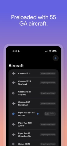
60 GA aircraft with full POH data, including Cessna 172, Cessna 182, Piper Archer, Cirrus SR22, SR22T, Bonanza A36, Diamond DA40, DA42, Piper Seminole, Baron 58, Pilatus PC-12, TBM 960, King Air 250, Citation CJ3+, Vision Jet, and more — takeoff roll, landing distance, climb rate, crosswind limits, service ceiling, and gross weight. Adding an aircraft? Search by make and model to auto-fill performance data.
SMART FEATURES
• Best runway recommendation from current winds, using surveyed true runway headings for accurate crosswind math
• Headwind, crosswind, and tailwind components — including gusts
• Parallel runways (08L/08R) listed separately with correct lengths
• Route corridor advisory filtering by geographic proximity, not just a fixed radius
• Night flight detection with sunrise/sunset awareness
• Runway length vs. aircraft performance at actual density altitude
• IFR alternate requirement and FAA fuel reserve checks
• Shareable weather briefing text for your records
• Flight history log — tap any past flight to rerun the evaluation
• Smart airport code entry — CHD auto-resolves to KCHD
• 40,000+ airports worldwide with runway data from OurAirports
SAFETY
• Clear notices when NOTAM, TAF, or advisory data can't be retrieved — never a silent gap
• First-launch safety disclaimer — must acknowledge before use
• Density altitude is advisory-only — runway and performance factors handle hard limits
• Route hazards auto-expand on any No-Go — nothing hidden
• Content-aware SIGMET evaluation — convective SIGMETs are No-Go; turbulence and icing checked against your minimums
• 150+ automated unit tests covering the decision engine, corridor filtering, aircraft performance, and weather parsing
DATA SOURCES
All weather data comes directly from the FAA's Aviation Weather Center (aviationweather.gov) — the same source used by major EFBs. Runway data from OurAirports covers 40,000+ airports worldwide. No third-party APIs, no middlemen.
NOTICE
Flyable is a supplemental decision aid only. It does not replace a standard weather briefing from 1800wxbrief.com or other FAA-approved sources. Weather conditions change rapidly. Always verify data against official sources and exercise your own judgment as pilot in command. The developers assume no liability for flight decisions made using this app.