The Dolomites are a single massif. Administratively they are split between Trentino, South Tyrol and Veneto, and each of the three publishes its own data in different formats, with different vocabularies and at different resolutions. None has a mandate to publish beyond its own border.
Anyone who holidays here knows the result: a pass between two provinces is described twice and never together; two places a hundred metres apart in altitude read 9 °C and 25 °C purely because they sit either side of a line; a park twenty minutes from Cortina doesn't exist for Cortina if it sits in South Tyrol.
Dolomitic does not produce data — it reconciles it: what 32 official sources across the three sides publish, brought to a common vocabulary and a common altitude, in one list.
WHAT'S IN IT
• Weather for 94 places, brought to the same altitude. Where two sources disagree about the same place, the app shows both and states the difference, instead of quietly picking one.
• Over 270 webcams, each saying how old its frame is. When a frame has been stuck for days the image is shown faded: a photo of snow three years old misleads more than any label.
• More than two thousand villages and hamlets, searchable by name: pick your own, not the main town. The forecast comes from the nearest place, and the app says which and how far.
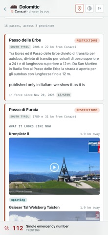
• The state of the passes, exactly as the responsible authority declares it: closures, restrictions, transit bans. Passes nobody declares stay on the list and say so: a visible gap is worth more than a silent one. Fourteen of sixteen have a webcam — it declares no closure, but shows whether there is snow.
• Over 3,500 trails in one list, with length, ascent, time and maximum altitude. For each: where to leave the car, which lifts reach it, which huts you can stop at, and the water along the way, with the kilometre where you meet it.
• More than 3,500 water points and over 370 public toilets, attached to the car park: that is where they are needed, not at a hut three hours up.
• Over 530 huts and bivouacs, more than 400 lifts, nearly a thousand parks and playgrounds, tourist offices and useful numbers, including the emergency number, which changes with the side: 112 in Trentino and South Tyrol, 118 in Veneto.
• Events and news in two lists, translated even when the source publishes in one language only.
• Transport sources: operators, ways in, valleys with restricted access. No copied timetables, only the link to whoever publishes them: a copied timetable ages in silence, the page behind it doesn't.
WORKS WHERE THERE IS NO SIGNAL
High up there is no network, and that is where the app is needed. Dolomitic separates what perishes — today's forecast, events, the passes — from what stays: where a place is, what a trail is called, where a hut or a fountain stands. The second half lives on the phone and never expires; the first, when it is old, says how old it is.
And before you set off you can take the map too: map, relief and trail tracks stay on the phone. The app says how much it weighs before it starts, and the space can be freed when you're back.
IT ALWAYS SAYS WHERE IT CAME FROM
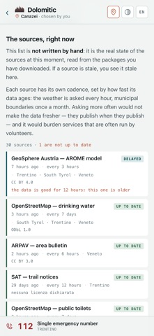
Every screen carries its provenance: which sources, from when, under which licence. The page "How it works" lists the 32 monitored sources with their state right now: which are answering, which have gone quiet.
PRIVACY
No account. No advertising. No analytics, no third-party libraries. The app downloads ready-made files, identical for everyone: the requests carry nothing about you. Location, if you grant it, stays on the phone.
THREE LANGUAGES
Italian, German and English, switchable inside the app. Place names are the ones the source publishes in your language.
THE DATA
meteo.report (Euregio) · ARPAV Veneto · Open Data Hub Südtirol · Autonomous Province of Bolzano · Veneto Strade · SAT, and further official sources. Map, trails, water, toilets and car parks from © OpenStreetMap contributors, ODbL 1.0.