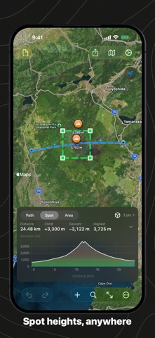
Tap a few points along a route and Geo Elevation draws the terrain under them: the elevation profile of any path, anywhere on Earth, with the numbers a planner needs. Then see the ground itself, in 3D.
The profile draws itself. Add a point, move a pin, drop a point on an edge: a second later the chart is back, with one sample every 30 metres along your path, up to a thousand of them. The profile passes through every pin you placed.
A chart that tells the truth. Sea level is a line; water shows as water. Distance, lowest and highest point, total climb and descent, average grade and the steepest hundred metres. Move along the chart and a ring on the map shows where you are. Drag to zoom into a climb; double-tap to see it all.
The terrain in 3D. One press samples the ground around your path, thousands of points, and shows it as a real surface with the map imagery on it and your path on top. Turn it, zoom in, raise the exaggeration to see a gentle hill. Or draw an area of your own and see just that.
Spot heights. Tap anywhere for the elevation of that one point.
Edit like a native app. Drag a pin with a loupe. Tap a pin for its coordinate and height, and delete it there. Undo and redo every step; on the Mac, ⌘Z. Add a point by typing coordinates, or from where you stand.
In and out. Import a GPX track, a KML route or GeoJSON, and older Geo Elevation files. Export the profile as GPX with elevations, as CSV, as GeoJSON, as an image, or as a PDF report; print it on the Mac and on iPhone.
Your units, your map. Kilometres or miles, metres or feet, each document remembers its own. Standard, satellite, hybrid and 3D map styles. Documents are plain GeoJSON, saved in iCloud Drive if you want them on every device.
One purchase for iPhone, iPad, Mac and Apple Vision Pro. No account, no subscription. Elevation data comes from our own server, ASTER and Mapzen at 30 m, worldwide; the app needs an internet connection to fetch it.
In English, German, French, Spanish and Japanese.